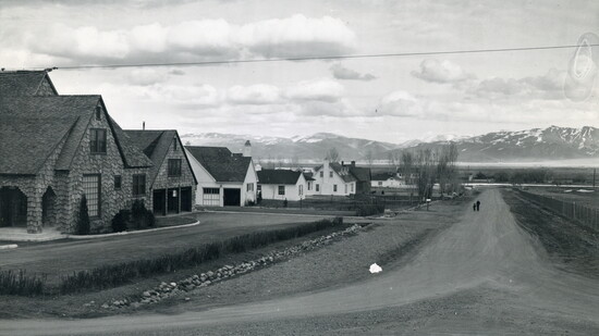
In the mid-1940s, there was talk of annexing the area southwest of Mt. Rose Street with the city of Reno, but residents were opposed. According to the Historic Reno Preservation Society, this area was “roughly defined as South Virginia Road on the east, Mt. Rose Street on the north, Hunter Lake Road on the west, and Mountain View Road on the south.”
Lawyers George Springmeyer and Clyde Souter, along with Dr. John Bibb, sought to preserve their already well-established way of life. The residents came together to propose what would eventually become the unincorporated town of Freedom.
Where Freedom Was
For modern Reno residents, perhaps the most fascinating part of the story is discovering where Freedom actually existed.
The community occupied an area that would eventually become familiar as neighborhoods and streets in southwest Reno. Clyde Souter, one of Freedom’s petitioners, had property in an area then called Drowsy Pines, part of the Interlaken Tract, around present-day Dartmouth Drive.
Dartmouth Drive provides one tangible connection to the area's past. Prominent attorney and lifelong Reno resident, William Horgan, and his family, lived at 1000 Dartmouth Drive. Horgan became involved in local civic and political organizations after returning from Army service following World War II.
The Meaning of Freedom
Springmeyer, a Nevada native and attorney, was one of the central figures in the movement. Souter, another attorney involved in the effort, was similarly active in Nevada politics after settling in Reno following a career that included serving as a district court judge. Dr. John Bibb rounded out the group identified as leaders in the creation of Freedom.
The name itself captured something fundamental about the dispute. This wasn’t simply a question of drawing a line on a map. For the residents involved, it was about maintaining control over their homes, their neighborhood, and the character of the place they had built.
Their involvement illustrates something important about the community: this wasn’t an accidental settlement on the outskirts of Reno. It was a deliberate response by established residents to the changing political landscape around them.
Freedom and the Politics of Growth
The establishment of Freedom reflected a larger tension in Reno's development: growth could bring opportunity, but it could also threaten the character and independence of established communities. Residents who opposed annexation sought to preserve their established way of life by creating a political and geographic distinction between themselves and the expanding city.
That makes Freedom more than an unusual footnote in Reno’s history. It represents one moment in the ongoing negotiation between individual property owners, neighborhoods, and a growing municipality. As Reno expanded, questions about boundaries and local control became questions about who had authority over the future of the region.
The people behind Freedom had chosen to draw their own line.
From Freedom to Modern Reno
Freedom didn’t remain a separate community forever. Over time, the distinction between Freedom and the surrounding Reno area disappeared, leaving behind a neighborhood that most modern residents would never recognize as having once been a separate community.
In 1954, Reno's annexation of Freedom triggered a fierce legal battle with the Interlaken Park Corporation. Led by attorney Clyde Souter, residents defended their rural lifestyle in court. However, in 1955, the Nevada Supreme Court ruled that municipal expansion was inexorable, officially absorbing Freedom into Reno.
However, the surviving landscape provides clues to what Freedom might have been like during its heyday. Names such as Drowsy Pines and Interlaken Tract belong to earlier chapters of the area's history, while Interlaken Park occupies land that was once more rural and agricultural and later became part of Reno's expanding residential landscape.
Political boundaries disappear. Rural roads become residential streets. Neighborhood names evolve. Homes remain while the communities and political arrangements that once defined them fade from memory.
And that may be Freedom's most interesting legacy.
You Can Still Find Freedom
There is no obvious sign today announcing that a town called Freedom once occupied this part of Reno. You won't find a municipal building or boundary marker identifying the community residents created in response to annexation.
But you can still find traces of it.
You can drive along streets that were once part of a very different landscape. You can look at homes that replaced the area's earlier rural character and find addresses connected to the lawyers, doctors, businesspeople, and families who helped shape this corner of Reno.
Although Freedom eventually became part of the city around it, its story remains a reminder that Reno wasn’t built all at once. It was assembled piece by piece, neighborhood by neighborhood, through decisions about land, growth, politics, and community.
Sometimes, those decisions leave behind more than a line on a map. Sometimes, they leave behind a town called Freedom.
In 1954, Reno's annexation of Freedom triggered a fierce legal battle with the Interlaken Park Corporation.