We had heard rumors for years about a place called Little Jerusalem in western Kansas. It was private property, protected by barbed wire, but we knew a guy who knew a guy who had been there.
It was supposed to be really cool.
Then, in 2018, the owners partnered with The Nature Conservancy who then partnered with the state of Kansas to create Little Jerusalem Badlands State Park near Scott City. The park opened to the public in 2020.
So if you’re blowing across on I-70 this summer on your way to Colorado or “more interesting places,” plan at stop at Oakley, exit 76. Head south on Highway 83 about 22 miles and watch for signs.
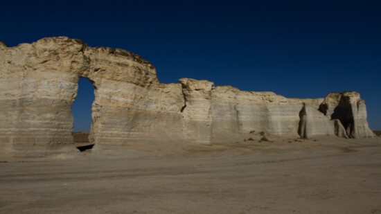
Looking nothing at all like the city in Israel, the Kansas version of Jerusalem is a mile-long valley of 100-foot-tall spires and cliffs encompassed by Niobrara Chalk formations. Giant clam fossils and other images embedded in the fragile rock remind us of the western interior seaway that covered this part more than 85,000 years ago.
Little Jerusalem Badlands State Park also reminds us that the Kansas prairie is not all flat, not all covered by grass and certainly not boring.
But imagine being in a covered wagon in the 1850s traveling the Smoky Hill Trail from Kansas City toward Denver. Moving at a speed of about three miles a day, you’ve put your faith in a higher power to see you through this journey.
The white formations on the horizon surely resemble the seven hills of Jerusalem. Thus, these white outcroppings became known as Little Jerusalem.
The state added the term “Badlands” to the name because it’s very much a smaller version of Badlands National Park in South Dakota.
The 300-acre park has restrooms, but otherwise limited services. Two trails allow you fabulous views of the formations. The Life on the Rocks Trail is the longest, winding 1.5 miles around the rim. Bring water, wear closed-toed shoes and watch where you step. Not only do cows still graze here, leaving their aromatic pies behind, but this is rattlesnake and copperhead country.
These craggy spires are also nesting grounds for ferruginous hawks. You’ll also see cliff swallows, sandhill cranes and numerous other birds. For that reason, and because they are not allowed in any Kansas state park, leave your drone in your vehicle.
It's important to stay on the trails because the terrain is so fragile. However, the park offers several ranger-led “off trail hikes” throughout the summer. You must register in advance by e-mailing sarakay.carrell@ks.gov.
And even though this is a day-use only park, the Nature Conservancy offers occasional nighttime tours that celebrate the dark skies of the area.
Little Jerusalem Badlands shares management with Historic Lake Scott State Park, eight miles to the south. A park since the 1920s, Lake Scott has, as the name suggests, a fishing lake, fully developed campsites, cabins and other services. Among the historic aspects of this park is El Cuartelejo, the remains of a seven-room structure believed to have been built by Taos and Picuris Pueblo Indians escaping Spanish rule in New Mexico in the mid-1640s. It is the most northern pueblo site in the U.S.
For more information, nature.org/littlejerusalem, travelks.com or ksoutdoors.com/State-Parks/Locations/Historic-Lake-Scott. Admission to Kansas State Parks is $5 per vehicle.
Since you are off of I-70, look for signs for Monument Rocks north of Little Jerusalem on the east side of Highway 83. Monument Rocks protrude 70 feet straight up from the prairie and was another icon for pioneers on the Smoky Hill Trail. In 1968, this became the first National Natural Landmark designated by the Department of Interior.
It is located on private land, but is open to the public at no charge. Be respectful.
And, since you’re off the beaten path, let’s stay there for another few miles and seek out Mount Sunflower, the highest point in Kansas. No, it’s not comparable to one of Colorado’s fourteeners, but it’s a much easier climb to the top.
At 4,039 feet, Mount Sunflower doesn’t have much of a snowcap this time of year, but it’s an adorable little spot with a picnic table and shelter, little library, and a mailbox filled with weird souvenirs from previous visitors.
There’s a good chance your GPS might not work out here, so you may wish to print out these directions.
From Oakley, take Highway 40 west for 65 miles. About a mile before you get to Weskan, a small brown sign points north on a gravel road. This is where you’ll probably lose your cell signal. Follow the gravel road for six miles until you see the big metal sunflower created by the shop class at Weskan High School.
To get back on I-70, continue west on Highway 40 to the Colorado border, then turn north on Highway 60.
There, your little journey to the middle of nowhere and you have survived. Indeed, you may be a better person for it.