With hundreds of miles of singletrack, Bend has become a mountain bike mecca in the Pacific Northwest. For those who live here, that means a seemingly endless amount of mountain biking trails to experience as we enter the 2025 season.
If you want a new singletrack challenge on Bend’s westside, check out three of my favorite 20+ mile loops. Then, grab a trail map and start linking some of your favorite trails together!
Beginner Loop
Start: Phil’s Trailhead
Route: Ben’s → Pine Drops → Upper Whoops Access Road (via 310) → Upper Whoops → Lower Whoops → EXT → Phil’s
Distance: ~20.6 miles // Elevation gain: ~1,917 feet
If your average ride is around ten miles, this Phil’s beginner loop is a great place to test your stamina. It is also an excellent option for longer family rides as it has the most intersecting trails to cut the ride short if your kiddos, or you, can’t make it.
It begins with a 5.5-mile climb up Ben’s, a green (beginner) trail. Besides one techy and fun rocky section, the trail is relatively smooth as it climbs just over 700 feet. Ben’s is a one-way trail (climbing only), so you won’t need to worry about descending riders or blind corners.
From Ben’s, connect onto Pine Drops, another green trail, climbing two miles and 475 feet. Once at the top, take a left on Forest Road 310, then a right in roughly half a mile on the Upper Whoops Access Road (signs mark the way). Two more miles and 670 feet of climbing will put you at the Shooting Star Snow Shelter.
Now, it is time to descend! Upper Whoops is a flowy, two-mile blue (intermediate) trail with fun turns and a few rooty sections. While there aren’t many technical trail features, sections of Upper Whoops can get pretty fast. Also, as of now, Upper Whoops is a two-way trail, and some people occasionally climb it, so keep an eye out as you descend.
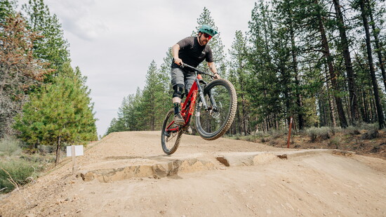
Upper Whoops connects to Lower Whoops, a two-mile blue descending-only trail. You’ll get to practice your jumps here, as Lower Whoops is littered with them. Fortunately, there are no mandatory gaps, and every jump is rollable.
Connect on the half-mile EXT trail — a green trail climbing roughly 60 feet — at the bottom of Lower Whoops. From there, connect onto Phil’s, a descending-only trail stretching nearly six miles back to the trailhead.
While most of Phil’s is green with fast, pedal-flow, a rocky section kicks things up a notch. You will know you are getting close as Phil’s crosses a forest road, enters a canyon, and are out when you see the Flaming Chicken (just trust me). From the chicken, you only have two miles to the trailhead.
Intermediate Loop
Start: Cascade Lakes Welcome Station
Route: Ticket to Ride (heading west/clockwise) → Voodoo Child → Voodoo → Ben’s → Pine Drops → Phil’s/Storm King Access → Storm King (North) → Storm King (South) →Catch and Release
Distance: 20 miles // Elevation gain: ~1,420 feet
Starting at Cascade Lakes Welcome Station, head west on Ticket to Ride for about 2.5 miles before connecting onto Voodoo Child. While both trails are rated green, you’ll find them a bit more rocky than Ben’s or Phil’s, upping the challenge just a bit.
Voodoo Child will connect you to the blue-rated Voodoo, providing relatively smooth sailing aside from punchy climbs. Voodoo will eventually end on Ben’s, climbing the trail's remaining 1.5 miles and 170 feet. From Ben’s, jump on Pine Drops, climbing its nearly 500 feet and two miles before connecting on the Phil’s/Storm King Access trail (just to the left of Pine Drops as you come out).
The Storm King Access trail will put you at the start of Storm King. Stretching over 8.5 miles, the blue Storm King trail is broken into “North” and “South” sections, divided by the highway. A true trail biker’s paradise, Storm King matches long, fast, flowy descents with punchy, sometimes technical climbs.
Completing Storm King connects you to Catch and Release, where you will turn left (northeast-ish) and head back to the trailhead. The two miles spent on the blue-rated Catch and Release will have you going up and down like an EKG before crossing the highway at the welcome center.
Advanced Loop
Start: Skyliner Trailhead
Route: Tumalo Ridge Trail → Tumalo Ridge doubletrack → Swede Ridge → Swampy Lakes → South Fork → SF to Tumalo Creek (connector) → North Fork → Metolius-Windigo → Mrazek → Farwell → Tumalo Creek
Distance: 23 miles // Elevation gain: ~2,700 feet
The advanced loop has several trails to piece together, but it is pretty straightforward once you’re riding. Trust me, the struggle will be worth it — this loop has two of the best descending trails in all of Bend.
Tumalo Ridge Trail will be a grunt as it ascends over 600 feet with some rocky bits and punchy climbs. Don’t worry, this blue trail gives way to some fun downs before switching to an old fire road, the Tumalo Ridge doubletrack.
After the doubletrack, jump onto Swede Ridge, an undulating blue with one particularly steep climb (walking it is okay!). After nearly two miles, Swede Ridge ends abruptly, and you’ll take a right on the Swampy Lakes trail, a blue with some technical roots and one stream crossing.
In just half a mile, you’ll be at South Fork, a proper black (advanced) trail descending nearly 1,000 feet in three miles. Rocks, roots, high speeds, and optional side jumps await as you begin your plunge. Keep your eyes down the trail for hikers and the occasional mountain biker coming up!
At the bottom of South Fork, continue onto the SF to Tumalo Creek connector. This will take you to the North Fork climb, a manageable four miles and 1,100 feet. The trail has spectacular views of Tumalo Falls before diving back into the dense forest. More waterfalls will be on either side of the trail as you pedal up through this truly spectacular zone.
The climb is almost over, just another hundred feet on Met-Win through some fun, rooty technical sections. Met-Win gives way to a mostly descending mile-and-a-half of Mrazek that will be a little rooty, a little rocky, and probably very sandy.
Don’t miss the turn onto Farewell — the other major descent on this loop, dropping over 1,100 feet in three miles. Farewell starts in the forest before opening up to spectacular views of the Cascades and Tumalo Falls. The terrain is rough and chunky, with fast sections, tight turns, and a lot of exposure. Be careful and have fun!
Farewell ends at the Tumalo Falls Trailhead, where you will jump back on the Tumalo Creek connector, a mellow green trail that will take you back to the Skyliner Trailhead. Watch for hikers!
Fun for All
Don’t let the mileage stop you from trying one of these loops. The beauty of Bend trails is that we have so many, and there is likely a cutoff nearby if you bite off more than you can chew. If you’re worried about whether you can make it, or you’re bringing kids along with you, each loop has cross trails that can potentially make things shorter.
The beginner loop has several optional trails to make things shorter if needed — MTB Trail, KGB, and Voodoo. These allow you to get off the “climbing only” Ben’s Trail and return to the parking lot. The intermediate loop has several cutoff options as well. Depending on where you are, trails like C.O.D. or Grand Slam can get you back to your car if needed.
Cutoffs become trickier with the advanced loop, especially after the South Fork descent. North Fork is a climbing-only trail, so if you need to turn back, you must walk your bike down.
Look at a trail map and see what you can manage. Try one of these larger Bend loops or create one of your own!
See you out there!
Mountain Bike Trailhead Locations
Beginner Loop
- Phil’s Trailhead
- Park at Shevlin Commons
- 18920 Northwest Shevlin Park Road, Bend
Intermediate Loop
- Cascade Lakes Welcome Station
- 18390 SW Century Drive, Bend, OR 97702
Advanced Loop
- Skyliner Trailhead
- Travel west on Skyliners Road (County Road 4601) approx. 10 miles